

Lassen Peak volcano:The Cascades
World volcano Profiles >North America > Lassen Peak
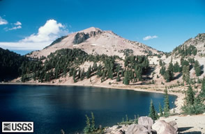 Lassen Peak is a volcano in California within Lassen National Volcanic Park and is the southernmost volcano within the Cascades. The summer season is brief and the winter snow fall can reach 50ft!It is considered the the volcano most likely to erupt again on the west coast. The American tribes called the mountain Amblu Kai meaning Mountain ripped apart or Fire mountain.It last erupted between 1914 and 1921.
The Geology bit
Unlike its volcanic Cascade cousins Lassen is not a strato-cone volcano but there are summit craters. Lassen Peak at 3187m (10457ft)is however the world largest a dome.Thick dacitic magma has been squeezed out onto the surface like toothpaste from a tube and formed the mass of the volcano. Also within the park are cinder cones,shield volcanoes and the elusive quartz basalt!
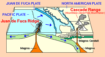 As part of the Cascades Lassen Peak was formed due to the subduction of the Juan da Fuca plate beneath the North American plate forming the Cascade Volcanic Range. Fluids from the subducted oceanic plate have caused melting of the the mantle wedge above the plate and this melt or magma has then risen to the surface and erupted gradually forming the cone of the volcano.
600,000 years ago a strato-volcano called Mt.Tehama erupted creating a huge caldera. After this thicker rhyolitic and dacitic lavas erupted forming a field of domes such as Eagle peak on the nothern flank. Lassen Peak started as a volcanic vent but as the thick dacitic lava was extruded the vent was blocked. The extrusion would have lasted around 5 years and caused lots of earthquakes as it split the old northern flank of Tehama. eruption took place a the end of the Pleistocene and the area was subsequently glaciated.
In 1914 the volcano came to life on May 30th with an eruption of ash and steam. These smaller ejections of material did not contain new magma just shattered old dacite. In May 1915 glowing lava was erupted from the summit and flowed down the side of the volcano in an effusive way- non explosive. Blocks of lava would break away and fall down the slopes. On May 22 a large explosion cloud rose 9000m ( 30,000ft) into the atmosphere. Ash fell up to 300 miles away and a pyroclastic flow moved surged down the NE slope. Some bombs from the explosion reached 8 miles away. The volcano continued to erupt in a smaller way until 1917. Eruptions tended to be greater in the spring when melted snow water would percolate the volcanoes rocks and turn into pressureised steam.
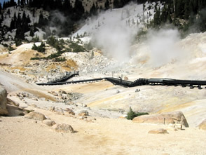 Bumpass Hell! This geothermal area is really is called that after Kendall Bumpass who lost his leg here in boiling mud. This 16 acre area has some of the best Geothermal features in the Cascades.The carved out Andesitic hollow contains has boiling mud and superhot fumaroles.
USGS:Lassen Peak links
USGS: Lassen Peak fact sheet
What to see and How to see it?
The park is open all year but access is restricted by snowfall durng the winter months. The Park roads have full access from late May to late September. Some trails don't open until July 1st so check first. There are over 150 miles of trails The Lassen park road( Highway 89) meanders for 30 miles through the western half of the park and is the only made up road. There are two entrances one in the South West near Sulphur works and the other in the North West at Manazanita Lake. The visitor centre at Manzanit is within the Park whereas the one at Mineral is 8 miles south of ther southern park entrance in Mineral. Both are open 8-4.30 pm. As with all USA national Parks you pay an entrance fee and are provided with a map.
Most of the main attractions are more accesible from the southern park entrance. Half way stop along the road Summit lake is the start of many trails and provides a busy camping area beside a cool blue lake.
Sulphur Works is an area of hydrothermal activity accessible along an easy trail (300m) . Mud pots, fumaroles and springs bubble to the surface at 76 C and have a high sulphur content. This may be where the original vant of Mt.Tehama was. Stick to the trail as the cruest in hydrothermal areas is thin and can collapse.
Bumpass Hell is found along a slightly longer trail (5km round trip).Watch your step as this area is named after a man (Kendall Bumpass) who lost his leg in the hot mud here in 1864. The bowl of geothermal activity has wooden platforms to view the activity safely.
The summit of Lassen peak is reachable by a reasonably fit walker and is a 8km 4-5 hour round trip. It is a steep zig zag trail and starts from the car park near road mark 22. Unusually for a lava dome the summit of Lassen Peak does have craters from which Dacite lava has oozed. The trail descends into a depreesion at the top then reascends to the real summit at 3187m (10,457ft).
In 1915 the violent eruption devastated a wide area which is now originally called " Devastated Area ".This area was denuded by the eruption and stripped of trees and other vegetation.
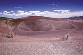 Cinder Cone(225m,750ft): a 1.5 mile trail from the Butte Lake Ranger Staionleads to the base of Cinder cone and another 0.5 miles to the top plus a 1 mile rim walk makes a 5 mile roundtrip. Last active in 1851 the cone is a beautiful example if a scoria cone formed when small fragments of lava are ejected into the air from a vent and form a cone where they fall. Similar activity to the subsidary cones on Mt.Etna or the current activity on Stromboli.
Students of Geology will have learnt that you don't get olivine and quartz in the same rock - well here you do! Its unusually a quartz basalt formed when a basaltic lava was contaminated with an acid high silica lava. The quartz appears as Xenocrysts (foreign crystals) and are usually bigger than the groundmass of the basalt in which they sit. Bombs cover the lower slopes.
Cinder Cone(225m,750ft): a 1.5 mile trail from the Butte Lake Ranger Staionleads to the base of Cinder cone and another 0.5 miles to the top plus a 1 mile rim walk makes a 5 mile roundtrip. Last active in 1851 the cone is a beautiful example if a scoria cone formed when small fragments of lava are ejected into the air from a vent and form a cone where they fall. Similar activity to the subsidary cones on Mt.Etna or the current activity on Stromboli.
Students of Geology will have learnt that you don't get olivine and quartz in the same rock - well here you do! Its unusually a quartz basalt formed when a basaltic lava was contaminated with an acid high silica lava. The quartz appears as Xenocrysts (foreign crystals) and are usually bigger than the groundmass of the basalt in which they sit. Bombs cover the lower slopes.
The slope is loose and steep but well worth the climb. Once a the top you can see the triple craters rims from differnet eruptions, encircle the craters and even descend in the cone. There are trails marked and leaflets to guide you. Wear your gaitors and take a pole.
Other Highlights
Devils kitchen trail: 3km one way trail to Hot Springs and MudpotsTerminal Geyser (1.4km)and Boiling Springs Lake (4.3km) trail . Starts along the Devils Kitchen trail and the Pacific Crest trail. Area of Hot springs and a roaring fumarole.
Mount Harkness (382m) trail:6km round trip to the summit of this small andesite shield volcano. Starts from Juniper Lake.
There are 5 campsites along the Lassen Park road. Other accomodation is mostly outside the park but you can stay at the Drakesbad Guest Ranch.
National Park Accomodation List