

 Mt St Helens volcano:Cascades
World volcano Profiles >North America >Mt St Helens
Mt.St.Helens is a volcano in The Cascades Range of the North Western USA which famously erupted in May 1980 with a dramatic illustration of how powerful the volcanoes of the Cascades can be. The volcano is 96 miles south of Seattle and 53 miles NE of Portland. Prior to 1980 it was nicknamed "Fuji" as its conical cone was pristine white with snow, beautiful and surrounded by forests and lakes - now its Awesome!
The Geology Bit
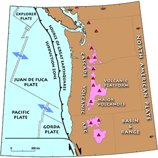
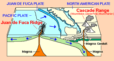 Mt St Helens is a stratovolcano within the Cascade Volcanic range in Washington State and had been dormant for 100 years prior to 1980. As an Eastern remant of the Pacific Plate, the Juan da fuca plate,has subducted beneath continental North America the Cascade volcanic chain has formed. The Mt.St.Helens volcano has been active for around 40,000 years but the now damaged cone we see today has formed over the last 2,200 years - pretty darn quick!The largest explosion of Mt.St.helens happened 3500 years ago which produced 13 times more material than in 1980.
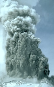
The volcano is highly explosive and erupts in the Plinian style like Vesuvius. Sudden violent explosions are accompanied by towering clouds of hot ash, dust and rocks thrown high into atmosphere. Pyroclastic flows and volcanic mud flows called Lahars flow down the mountain at speed and consume the surrounding landscape. lavas from basalt to andesites have been erupted forming layers of ash and lava.
In many stratovolcanoes a central summit crater has dome of dacitic lava which is squeezed out of the main vent , similar to Montserrrat. In 1980 this did not occur and instead a crypto dome formed (crypto means hidden) causing the Northern slope of the volcano to bulge and grow. From mapping the deposits around the volcano it seemes that lateral blasts and side domes were not unprecedented.
May 18 1980 Eruption
On May 18 1980 Mt.St.Helens produced an enormous lateral blast which obliterated everything for 20 miles north of the volcano. The summit decreased from 2930m to 2550m and a gaping crater 1.5km wide was created.
The sequence of events that occured had not been witnessed before as until then geologists had always seen volcanoes erupt upwards but this was different this was sideways!
In March 1980 earthquakes and a phreatic(steam) 2km eruption column alerted the USGS that the volcano was certainly waking up. Throughout the spring the mountain continued to splutter and steam the northern side of the mountain was bulging out by 1.5m/day. A 5 miles exclusion zone was placed around the volcano and famously Harry Truman owner, of the Spirit lake lodge resort, refused to leave.
On the morning of May 18 Geologist David Johnson was on a ridge 10km north of the volcano when a 5.1 earthquake struck. Suddenly the bulge on the north side of the volcano slid downwards in a massive landslide at 300km/hour and crashed into Spirit lake causing an enormous wave of water the rest of the landslide ploughed down the Tootle river valley and mixed with vast quantities of lake water and ice . Davids last message was to his colleagues in the nearby Vancouver USGS base ( not Canada) "Vancouver,Vancouver .. this is it!"
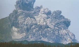 The landslide uncorked the magma in the crypto dome and released the pressure. The gas in the magma instantly expanded and shattered the rocks at supersonic speed creating a lateral of blast ash and hot rocks which overtook the landslide at reached speeds of 1,000km/hour (670 miles/hour) . The blasts power has been estimated at 500 times that of Hiroshima. 600km2 of forest was blown away and trees combed down like hair, sap exploded in trees in the intense heat. Trees up to 20 miles away were engulfed in the blast 4 times the distance of the exclusion zone.
The third string to Mt.St.Helens bow was a 19km (12miles) high eruption cloud which powered vertically out of the volcano in a matter of minutes. The cloud turned day to night and ash fall was heavy. Lightning crackled around the cloud.
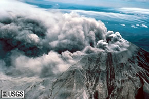
Mudflows or Lahars formed within minutes of the eruption. lake water,melted glacier ice, hot ash and debris all combined to send hot ( 29-33C) cement like flows down the Toutle river. Pyroclastic flows started to form from the crater just after the blast as fresh magma came into contact with the air. Material appeared to overflow the craters edge and flow down the Toutle valley as a grey turbulent cloud. 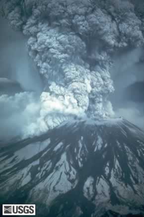
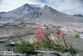
Harry Truman and David Johnson along with 55 other people did not survive. Both have had ridges named after then within the Mt.St.Helens national monument. The area within the monument is being left to recover naturally. Within 8km of the volcano all trees were obliterated, from 8km to 30km flattened and outside this dead but left standing. Outside the boundary loggin companies have replanted trees.
USGS Current Activity Update
How volcanoes work:MtStHelens
What to see and How to see it?
 The best time to see Mt.St.Helens is the the summer, as winter weather can make the roads impassable and it is very cold. If travelling from the west and Seattle you can see a film about the eruption at Junction 49 on Interstate 5 at a Cinedome. After this the best place to head for is the Coldwater Ridge Visitor centre on highway 504. As you move on you will see grey stumps and ash covered landscape before arriving at the Johnston Ridge Observatory.
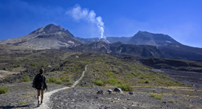
Here a panorama of the plain of pumice and avalanche debris opens up with the gaping crater at the centre. You are 5 miles away but it is absolutley enormous. This is where David Johnson made his last call from and the blast reached this spot in seconds. The visitor centre has good informative displays, a film and advice on walks in the area. Short walks from here need are not hazardous.You will get dusty with grey ash.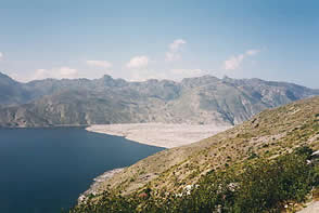
Longer walks are available and the 5.2km walk to Harrys Ridge gives you an even closer view of the volcano, with spectacular views over Spirirt Lake.You can either return to the observatory or continue to Norway pass (19km)and the junction with Road 26 (23km) but these are a bit too long for a return so you will need a pre-arranged pick up at road 26.
Windy Ridge at 1200m on the SE side of spirit lake is a spectacular viewpoint and has outdoor talks throughout the summer.There are however over 360 steps from the car park up a small hill but the view is worth it. From here you take the Truman trail to Harrys ridge across the pumice plain and the closest you can get to the lava dome. It is a 22km round trip or 14 miles so quite a step if you are not a seasoned walker. Stay on the path as the landscape can de deceptive and it is a scientific research area.
Climbing the volcano from the south side is a 12 hour round trip and not for the inexperienced as it gets pretty rough.You will need a permit which is valid for 24 hours and only 100 people day are allowed. If you dont want to climb helicopter rides are available from where you ll get a great view of the new lava dome.
Mt St Helens Helicopter tripsApplebee aviation Helicopter trips
To the top / Uk shop / USA shop USGS Mt St Helens Visitor info(maps, visitor centres )
USGS Cascades Volcanic Observatory
USGS Fact Sheet
Forestry Service Volcanic Guide to Mt.St.Helens
Global Volcanism project
Volcano World:Mt.St.Helens