

Northern Iceland Volcanoes
World volcano Profiles >Europe > Northern Iceland
 Northern Iceland contains the volcanic areas of Northern Iceland straddle the Mid Atlantic ridge and contain Lake Myvatn,Krafla volcano and Viti or Hells Crater. Iceland is purely volcanic island and contains 130 volcanoes. It is often called the "Land of Ice and Fire". This name comes from a the combination of 130 volcanic mountains, hydrothermal fields and extensive glaciers the largest of which is the Vatnajokull Glacier.
Driving in Iceland
An offroaders heaven! The main road around the perimeter of Iceland is paved but the interior roads are rough rock and gravel tracks and will involve river crossings so experience of 4WD , a map and of course a 4WD are essential. Make sure the petrol tank is full as petrol staions can be few and far between and non existent in the interior. Mountain Roads can be closed until June and those roads with an F prefix are only passable with a four wheel drive.The sign Malbik Endar means the paved road is about to run out - so slow down. Some river crossings can have water 4ft deep.
The Geology bit
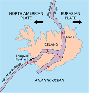 Icelands volcanoes owe their origin to the combination of two geological forces. Firstly Iceland sits upon the Mid-Atlantic Ridge ;this where the North American plate and the European plate are being pulled apart at about 5cm/year. As the Atlantic gets wider magma wells up from the mantle below creating new oceanic crust below the sea surface and new land above. The Mid-Atlantic ridge extends all the way to the South Atlantic as a narrow zone of spreading,rifting and volcanic activity on the ocean floor.
Secondly,Iceland rises above the sea due to an extra concentrated jet or pulse of magma called a hot spot or mantle plume which provides an extra boost of molten rock.
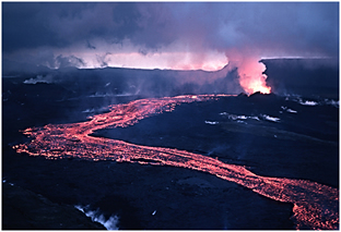
The rocks erupted are similar to Hawaii in that they are mainly basaltic and produce lava fountains and flows.Iceland has extensive Geothermal activity and is home to the original Geyser. Geothermal activity also provides home with hot water and electricity.
All over Iceland you will see columnar basalt columns. These polygonal sided columns form naturally as flood basalts cool and contract. Fartifoss waterfall is a good example of these ( its in southern Iceland ). Icelands volcanic regions of current activity are governed by the Mid Atlantic ridge which splits the country in two. Iceland deserves its own website to do it justice so here I have just given the volcanic highlights but rest assured there are many more things to see than just the big names.
What to see and How to see it?
Northern Iceland has seen of the most dramatic and recent activity in Iceland. The main sights are accessible from Icelands perimeter road but a 4WD will cope better with the tracks.
Highlights of the area
Krafla Central volcano:
one of the most popular volcanic sites in Iceland: Geothermal sites.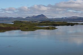 Namafjall Geothermal field:
5km south of the Krafla calderaLake Myvatn:
Shallow lake with 50 islands and pseudo crtaers caused when lava has flowed inthe lake and exploded. Great for bird watching but lots of midges. Camping available.Viti or Hells crater:
A 320m wide crater with a blue lake within the Krafla caldera on it s western rim.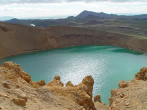 Leirhnjukur Hill and Solfataras:
Last active in 1984 there are multi coloured deposits from steaming fumaroles, mud pots and lakes. From the bottom of the hill you can make your way along the still steaming fissures.Hverfjall tuff ring:
:This 163m high tuff ring with 1km wide crater is reachable by dirt track from Reykjahlio. Walk round the rim and look at the bedded tuff (ash) deposits caused by an explosion as magma entered water.Ludent crater :
: The crater is 1km wide and 70 m deep and was used as a training ground for Apollo astronauts including Neil Armstrong. Found along a track 5km to the SW of Hverfjall.Dimmuborgir or dark fortress: A 20m deep lava pond whichdrained lava and left behind a series of dramatic columns , benches and lava caves. Walk map available from the car park located to the SW of Hverfjall.