

Ruapehu Volcano New Zealand
World volcano Profiles >New Zealand>Ruapehu
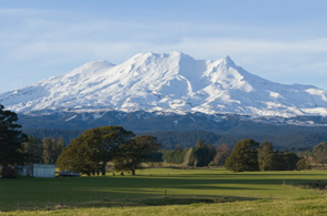 Mt.Ruapehu volcano lies within Tongariro National Park, a world heritage site,along with two other large volcanoes Mount Ngauruhoe and Mount Tongariro. The volcanoes are within the 2 million year old Taupo volcanic zone and Ruapehu marks its south western boundary. Ruapehu is New Zealands most active and largest volcano and the its triple summit is the highest point on North Island. Ruapehu is home to North Islands Whakapapa ski slopes and only glaciers. Ruapehu is Maori for "exploding pit" .
The Geology Bit
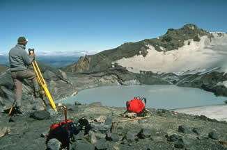
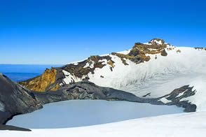
 The volcano has three peaks Tahurangi (2797m),Te Heuheu (2755m) and Paretaitonga (2751m) with the active crater nestling between them. There is a crater lake at the summit which can contain up to 10 million cubic meters of acidic water.
In 1945 and 1995 the volcano ejected the water out of the crater onto the glaciated slopes. Lahars flow from the summit and and are a great hazard and have occured throughout the volcanoes history.Major eruptions are roughly every 50 years with 60 minor eruptions since 1945
The volcano has three peaks Tahurangi (2797m),Te Heuheu (2755m) and Paretaitonga (2751m) with the active crater nestling between them. There is a crater lake at the summit which can contain up to 10 million cubic meters of acidic water.
In 1945 and 1995 the volcano ejected the water out of the crater onto the glaciated slopes. Lahars flow from the summit and and are a great hazard and have occured throughout the volcanoes history.Major eruptions are roughly every 50 years with 60 minor eruptions since 1945
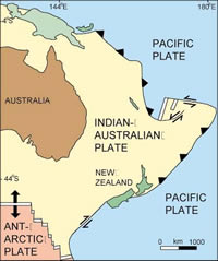
Ruapehu is an andesitic stratovolcano and consists of andesite lavas and debris which have accumulated over the past 300,000 years. The volcano sits above a subduction zone or destructive boundary within the extensional basin of the Taupo Volcanic Zone caused by the the subduction of the Pacific plate in an easterly direction beneath the Indo-Australian plate. The decending slab of cold and dense Pacific Oceanic crust releases fluids which aids melting of the mantle wedge above. The magma then rises to the surface through weaknesses and cracks in the crust above and erupts as a volcano. The Extension of the crust in the TVZ allows the magma to well up in large amounts and break through the thin crust or pond ust below it.
Volcanoworld: Taupo Volcanic ZoneChistmas Eve lahar 1953: Tangiwai Disaster
On Chistmas Eve 1953 the tephra dam holding the crater lake back collapsed and a lahar rushed down the Whangaehu river. The lahar washed out the Tangiwai bridge just before an express train ran through. The driver was unable to stop the rain in time and 6 carriages plunged into the river killing 151 people.
1995-1996 eruptions
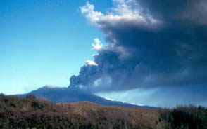 The eruptions of Ruapehu made the global headlines when skiiers were pictured on Ruapehus slopes with an eruption cloud behind. The volcano had been rumbling since November 1994 and the crater was warming up. Lahars flowed down the Whangaeu river during september 1995.
2006
Eruption sends water column 200m into the air.
2007 March 18
The tephra dam to the crater lake bursts and lahars flow down the Whangeahu river. 1.4 millon cubic metres of material. Road and rail were severely disrupted for a day. No one was hurt. On September 25 a sudden phreatic eruption injured a teacher who was in the summit area when a rock landed on his leg. Lahars travelled down the mountain.
In September 2007 the summit area was closed to visitors so it is vital to check the status of the volcano.
www.teara.govt.nz:Geological Background of New Zealandwww.Geonet.org.nz Webcam
www.Geonet.org.nz Level of activity updates
www.Geonet.org.nz Ruapehu
ww.natureandco.com: Volcanoes in New Zealand
What to see and how to see it.
 Ruapehu lies within Tongariro National Park, 40km SW of the southern shore of Lake Taupo. It is possible to stay on the shores of Lake Taupo and go to Ruapehu for the day. You can also make National Park Village at the base of the volcano your base. The volcano has two ski areas, Whakpapa and Turoa which provide accommodation, services and lifts up to. The park is named after the Tongariro volcanic complex which inlcudes Mt. Tongariro and Mt. Ngauruhoe which featured in The Lord of the Rings.
www.peakbagging.co.nz Mt_Ruapehu
www.mtruapehu.com : Skiing and much more
www.snow.co.nz
Bayview Chateau Tongariro
www.metservice.co.nz : Ski and snow reports
Crater Climb
 The crater area is potentially a highly explosive area and therefore no ascent to the crater should be made if the authorities have closed the summit. Check the links above for access information. The Whakakpapa Visitor Centre will provide route conditions and activity updates. Check before you set out. If the chairlifts are not running its unliklely that the volcano can be safely climbed!
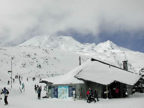
When the summit is open and safe the best time to climb is in the summer.Winter ascents require alpine climbing experience and equipment. As the slopes of Ruapehu are home to the Whakapana Ski Area you can make use of two chairlifts up to 2020m to the Knoll Ridge Chalet from Iwikau Village. The round route from the top of the ski lift takes about 5 hours and is 7km. If you want to ascend all the way by leg power its 10km and takes about 7 hours from the top of the Bruce road. The route to the crater is not marked, so it might be wise to go on an organised ascent with a guide if you are inexperienced.
Dome Ridge can be icy and narrow and should not be attempted without the proper equipment if there is ice present.
 Route 1
Ascend to Knoll Ridge Chalet ( New Zealands highest cafe) and follow the t-bar line up to the last pylon. At the end of the valley climb upwards to behind Glacier Knob. Follow a zig zag path up onto Dome ridge and onwards to Dome Shelter.
Route 2
Best attempted when there is very little snow. Take the Waterfall Express chairlift and bear right from the top over towards Restful Ridge. Follow the rocky ridge towards towards the crater. At the end of the ridge follow a zig zag trail up to Dome ridge and then up to Dome Shelter. Ruapehu is a very active volcano which can suddenly erupt. The weather can change quickly and it may be icy. The volcano will still be there tommorrow!!!
Other Activities
Tongariro Crossing
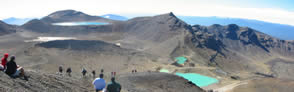 A one day trek (8-9hours) through across a dramatic volcanic landsape, one of the best day walks in New Zealand. Start out from National Park Village. If you are feeling fit you can climb Mt. Ngauruhoe or Mt.Tongariro. You will need to be shuttled from the start and end of the track .
Take adequate warm and waterproof clothing. Food,water and a map. Don't attempt the walk in poor weather or alone. Assess your fitness and experience and take advice.
A one day trek (8-9hours) through across a dramatic volcanic landsape, one of the best day walks in New Zealand. Start out from National Park Village. If you are feeling fit you can climb Mt. Ngauruhoe or Mt.Tongariro. You will need to be shuttled from the start and end of the track .
Take adequate warm and waterproof clothing. Food,water and a map. Don't attempt the walk in poor weather or alone. Assess your fitness and experience and take advice.
www.tonarirocrossing.org.nz : All you need to know
www.thetongarirocrosing.co.uk : Organised Hikes
www.tongarirocrossing.com : Shuttle bus comapny
www.natureandco.co.uk : Virtual tour of the walk
Links
www.visitruapehu.com:Onestop guide,accomodation,activities
www.newzealandtravelplanner.com
Global volcanism project