

 Santorini volcano Greece (Thera)
World volcano Profiles >Europe > Santorini
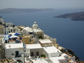
Santorini (Thera) is Greeces most famous volcanic island and lies in the Southern Aegean sea. Around 1650 BC a cataclysmic eruption blew the centre out of the island, foming a crescent shaped island which wraps around a lagoon 12km long by 7km wide. Surrounded by 300m high cliffs which extend a further 400m under water. It is the most active volcano in Greece, and has long been linked with the legend of Atlantis.
The Geology Bit
Santorini lies within the Southern Aegean Island Arc and owes its existence to the subduction of the African plate beneath the European plate along the ionian trench to the south of Crete. 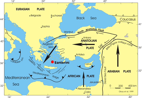
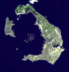 In 1650BC a catastrophic Plinian ( like Vesuvius)eruption blew the centre out of the island creating an eruption column estimated to have been 23 miles high. The explosion is thought to have caused a tsunami which devastated the northern shore of Crete to the south and precipitated the decline of the Minoan civilisation. The sea flooded into the caldera created by the evacuation of the magma chamber , hence the steep cliffs which extend below the waterline.
Unlike Pompeii it would appear that the population were able to evacuate before the final eruption as no human remains have been found in the ancient city of Akroteri. Hundreds of feet of ash were deposited by the explosion.There have been 11 eruptions since 197 BC the most recent being on Nea Kameni island in 1950. Most of the lavas are dacitic which means they are quite viscous and form domes and short lava flows.
What to see and How to see it?
Nea Kameni
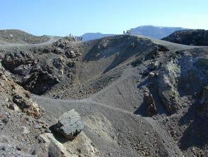 Boats depart from the port of Athinios and land at Kato Fira (Yialo)on Nea Kameni . A path from here goes across lava from 1925 before going up to the ashy slopes of Mikri Kameni . The path continues towards and around the main Dafni crater. Next onto 2 craters formed in 1940 which are steaming with fumaroles and bright yellow sulphur and up to the summit of the island at 127m. look out for breadcrust bombs along the way with their distinctive cracked crust. About 4 hours on the island should be enough to fully explore all the lava fields and have a good look round.
On the way back stop off at Palea Kameni to bathe in hot spring heated bay of Agios Nikolaos. You can climb to the 98m summit for a good view of the Santorini caldera and Nea Kameni. There is a cross section through a lava dome on the SE shore best viewed from the boat.
Akrotiri
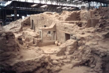 Excavations began in 1967 of the former Minoan city buried by the 1650BC eruption. You can get a visitors guide at the entrance to the site. Not much has been excavated yet but it is interesting to see how earthquake damage was repaired before the eruption took place. The ancient city was engulfed by pyroclastic flows.
Quarries
The thick deposits left by the eruption can be seen in two quarries one to the south of Fira and the other on the Akrotiri road. Layer upon layer of pumice and pyroclastic flow deposits in cliffs up to 20m high. You can even see the orignial soil layer from before the eruption.
Santorini Links
Global Volcanism projectStromboli Online:Santorini
Santorini.net
Decade volcano:Santorini
Wikipedea : Santorini