

- Lava Flows
- Ash Cloud
- Pyroclastic Flow
- Lahar
- Gas
- Tsunami
- Magmatic Quakes
- Monitoring
- Management
 Lava flows from volcanoes are rarely a threat to human life as the flow moves slowly enough to move away. Extensive lava fountaining can produce ash and tephra which can fall on grazing land or collapse roofs. Gas released from lava can cause air pollution and gas explosions from flows can be dangerous if you stand close enough. The main losses come from property and communications. Pahoehoe and aa-aa lavas present the most lava flow hazard whereas dacitic,andesitic and rhyollitic lavas present the more explosive eruption risk.
The rate at which lava flows is dependent on .
- Type of lava ,low silica basic lavas such as basalt have a low viscosity and produces pahoehoe. High silica and lavas such as dacite and rhyolite produce domes rather than flows.
- Terrain and slope steepness
- Whether the lava is channeled in a tube or channel
- How fast the lava is produced from the vent.
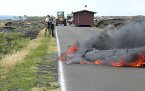
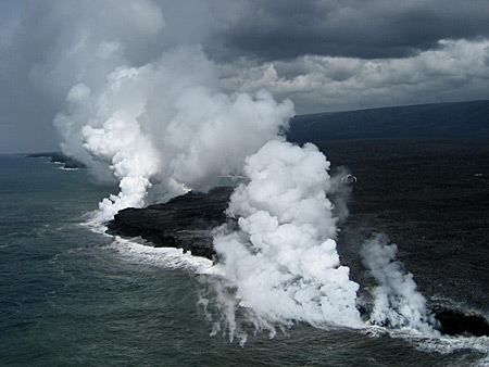
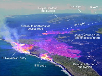
Hawaii:Kilauea lava flows
 In 1990 and 2010 a lava flow from Kilauea
engulfed and consumed the settlement of Kalapana.Between 1983 and 1998 lava flows from Kilauea also covered 13km of the southern coastal road to a depth of 25m in places. This eruption from the Pu oo oo vent is still continuing.
In 1990 and 2010 a lava flow from Kilauea
engulfed and consumed the settlement of Kalapana.Between 1983 and 1998 lava flows from Kilauea also covered 13km of the southern coastal road to a depth of 25m in places. This eruption from the Pu oo oo vent is still continuing.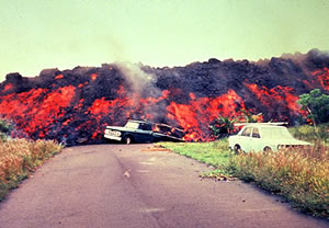
Ash clouds occur where a violent explosive eruption ejects volcanic ash into the atmosphere. Bouyed up by the force of the eruption and the small size of particle the ash(< 2mm) may stay aloft for 10s to 1000s of kilometres from the vent. In some case volcanic ash can circulate the globe. Ash is composed of small shattered fragments of rock and volcanic glass particles. When gas or water vapour expands dramatically within the magma rocks are blown to pieces by the sudden expansion- an eruption.
 Ashfall clouds can block out the sun, are often accompanied by a strong sulphurous smell and unlike snowfall does not melt away.Main problems are:
- Disruption to air travel, Volcanic ash is highly abrasive and will scour the windscren of and aircraft. Ash sucked into jet engine will remel and clog the engine causing engine failure.
- Roof collapse
- Poor visibility
- Acid coating on ash irritating lungs and eyes
- Contamination of water supplies
- Vegetation damage
- Increase chance of Lahar formation
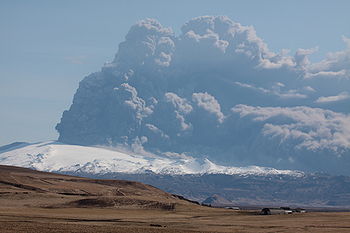
Eyjafjallajokull Ashcloud 2010
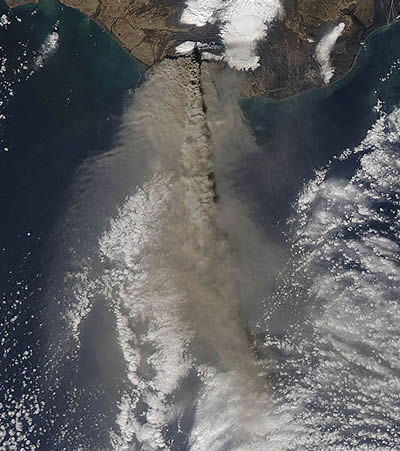 In spring 2010 Eyjafjallajokull,avolcano in Iceland,began an eruption which would effect all of Europe. On April 14 an eruption under the crater glacier started , the heat from the eruption melted the ice which then entered the veent causing amore explosive eruptionThe resultant ash cloud was blown south wards towards Europe.UK Airspace was closed from 15-23rd April, 4-5 May and 16-17 May.
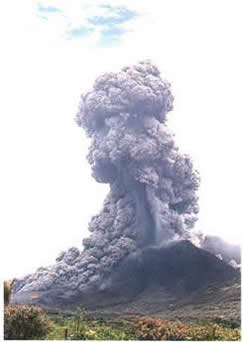
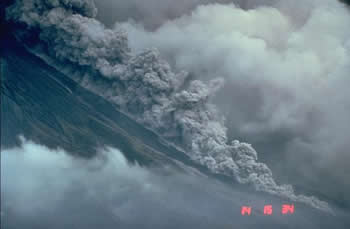 Pyroclastic flows (nuee ardente) are fast moving high density flows of hot rock framents,ash,dust and . They appear as a ground huggin billowing grey cloud that surges forward from the vent of a volcano. They can occur either as a result of dome collapse, collapse of an eruption column or a sudden explosion from a volacano. They consist of two parts a basal flow of rock fragments which hugs the ground and a billowing ash cloud that moves over the top.
Although the flow looks grey and fluffy it is lethal and will destroy all in its path. Temperatures inside the flow can reach 1000C and it can reach speeds of 80-100Km/hr and the flow will normally follow existing river valleys.
Pyroclastic deposits can be up to 200m deep and form unconsolidated slopes which are prone to lahar formation. Flows can also erode and melt glaciers then mix in with the meltwater to form lahars instantly.Pyroclastic surges are less dense and able to flow small hills they are colder at around 250C.
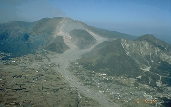
Montserrat 1995 to present
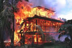
 The southern 2/3 rds of the Caribbean Island of Montserrat has been devastated by the eruption of the Soufriere hils volcano. Pyroclastic flows caused by dome collapse frequently raced down the surrounding valleys destroying the once verdant land sape,the capital Plymouth and the airport. 19 people were killed in June 1997.
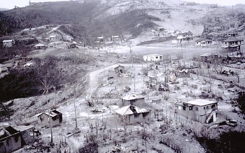
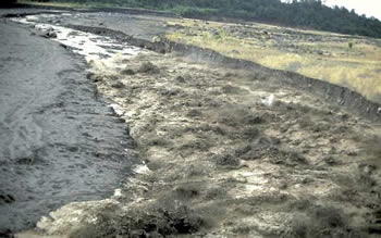 A lahar(Indonesian) or volcanic mudflow is a mixture of volcanc debris and either hot or cold water which flows down the side of a volcano. Lahars occur when large amounts of water quickly mix with either newly erupted volcanic material or old material resting on slope.
The water comes from either melted ice,breached crater lake, an engulfed river or rainfall.It resembles flowing concrete with particles from clay to boulder size, and gains new material as it erodes its bed. A lahar can move very quickly from a few meters/second to 10s of meters /second- faster than a man can run. These mudflows can also travel 10s of kilometres from their origin moving alon established river valleys.
Lahars occur mainly on steep sided stratovolcanoes where the combination of steep slopes,unconsolidated slopes,explosive eruptions,crater lakes and high altitude allowing ice formation, provide ideal conditions for lahar formation.Nevado del Ruiz 1985: Armero: Colombian Andes
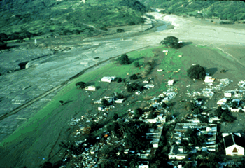 On 13th November 1985 Nevado del Ruiz erupted dactic tephra 19 miles into the atmpsphere. Pyroclastic flows melted ice and snow on the summit and created 4 lahars which sped down the volcano and into the valleys below. The unsuspecting town of Armero,30 miles away,was engulfed and buried by the mudflow killing around 20,000 people.23,000 were killed overall by the eruption. Armero was built on an old mudflow, scientists were aware of the imminent danger but government officials refused to take action to evacuate.
Mt Rainier: Cascades USA
Mt.Rainier is considered one of the most dangerous volcanoes in the world. Located in the Cascade range between MtSt Helens and Seattle.The volcano has the most extensive glaciers in the lower 48 states and the underlying rocks have been weakened by hydrothermal activity.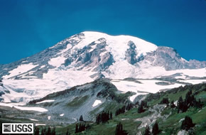 If an eruption occured massive lahars could travel north as far as Seattle and the Puget Sound.
 Magma contains gases which at the higher pressures deep in the earths crust are dissolved in the melt.These gases can escape into the atmosphere gently or violently. Gases can escape through the soil,hydrothermally,fumaroles or vents. As the magma rises the bubbles form and enlarge reducing the density of the melt and aiding its ascent. If the gas bubble volume exceeds the magma volume then an explosive eruption can occur and the magama become ejected as tephra.The most abundant gases are:
- Water H2O
- Carbon Dioxide CO2
- Sulphur Dioxide SO2
- Hydrogen Sulphide H2S
- Hydrogen H2
- Carbon Monoxide CO
- Hydrogen Chloride HCl
- Hydrogen Flouride HF
- Helium He
The most dangerous hazards to humans, animals and people are Sulpur Dioxide,Carbon Dioxide and Hydrogen Flouride. Sulphur dioxide aerosol ( very fine droplets)if ejected high into the atmosphere can reflect the suns energy causing cooling globally and effect the ozone layer. In 1991 the eruption of Mount Pinatubo caused a global temperature drop of 0.5 degrees C. So2 reacts photochemically with sunlight ,water,gas and oxygen and produces VOG a sulphur rich fog. water,dust.
 Volcanoes release 130 million tonnes of CO2 every year something that is not mentioned when people talk of global warming! CO2 is denser than air and will collect in hollows , if the concentration is more than 30% then this can be lethal to life.
Hydrogen Flouride is a plane yellow gas whih attaches itself to ash. It is an irritant to eyes and skin and causes degradation of bones and teeth. If livestock eat ash covered grass the flourine in the ash will poison and cause bone degradation and eventually death. HF can also cause a caustic acid rain similar to HCl.
When lava enters the sea it boils and vaporises the seawater. Chemical reactions occur which produce a white plume called lava haze or laze. The plume has a high concentration of Hydrochloric acid and a Ph between 1.5 and 2. This concentration is corrosive to skin,eyes,lungs and clothing- avoid standing in a laze cloud!
If a volcanic eruption quickly deposits a large amount of material in a body of water,such as a landslide, then a displacement of water occurs which radiates outwards. In the sea this called a Tsunami but can occur in lakes too. The Tsunami will move through deeper water with a long wavelength and will be undetectable by boats.When the tsunami reaches shore as the water shallows wavelength will shorten and the height of the wave increase. The Tsunami will surge ashore rather then break like a normal sea wave. A warning sign of a Tsunami is the the sea retreats exposing the seabed before the wave suddenly advances.A common misconception is that tsunami is do with the tide , this not so!
Krakatoa May 1883
 Krakatoa is a volcano near Java in Indonesia. In 1883 it erupted with the loudest sound heard in modern history. A series of eruptions produced eruption columns which collapsed producing pyroclastic flows which plunged into the sea displacing creating tsunmais. The tsunamis were 40m high and killed 90% of the 36,000 killed by the eruption.Cruelly those who surived the tsunamis by rushg to higher ground ere killed by pyroclastic floes which had raced out over the sea on a cushion of steam.
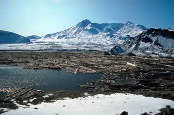
Mt St Helens
Mount St Helens in 1980 unleasheded a wave 250m high into Spirit Lake when the northern slope of the mountain slid into Spirit Lake. The wave was 6 times higher than the Krakatoa wave.
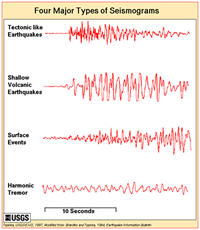
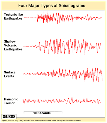 Magamtic earthquakes are caused by the mvement of magma within the volcano. They are often shallow and can damage property and set off landslides and rockfalls. They also indicate that the volcano is active and may be preparing for and eruption.
Long period events have been used to successfully predict volcanic eruptions Mount Redoubt,Alaska;Galeras,Colombia and Popocatapetl,Mexico, where thousands of people were safely evacuated from the largest eruption for a thousand years.
One of the leaders in eruption prediction is Bernard Chouet who has pioneered a technique of looking at long period earthquakes (harmonic tremors)beneath a volcano which are the result of gas being pressurised within the volcanoes plumbing. His theory was put to the test when the Mexican authorities evacuated 10s of 1000s of people away from Popocatepetl based on the prediction that there woud be an eruption in 2 days time. He was right, the eruption happened and noone was hurt. After the disaster at Armero caused by Nevado del Ruiz where warning signs had been disregarded this was a great success.
Mt St Helens
A magamatic earthquake was responsible for setting off the landslide which dislodged the bulge on the northern slopes of MtSt Helens which in turn released the pressure on the magma elow and caused a massive eruption.
Seismic Activity
Magamtic earthquakes are caused by the mvement of magma within the volcano. They are often shallow, less than 10km,and although only RS 2-3 ,can damage property and set off landslides and rockfalls. They also indicate that the volcano is active and may be preparing for and eruption. Networks of seismometers and tiltmetres can pick up earthquakes and changes in the surface,
Long period events have been used to successfully predict volcanic eruptions Mount Redoubt,Alaska;Galeras,Colombia and Popocatapetl,Mexico, where thousands of people were safely evacuated from the largest eruption for a thousand years.Bernard Chouet a Swiss Geologist has pioneered the use of long period events and harmic tremors to successfully predict volcanic eruptions.
Gas Emmissions
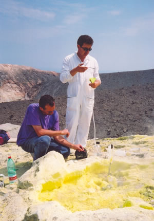
 Gas emmisions,particularly of sulphur dioxide,will increase as a volcano moves closer to erupting. Sulphur emmisions ncreased 10x before Pinatubo erupted in 1991. However just before the volcanoes erupt it has been observed that emmissions drop as gas escape pathways are blocked by hardened magma. This increases pressure within the system and makes the eruption maore explosive. Taking ground measurements is dangerous so geologists also use aerial sensors such as COSPEC (Correlation spectrometer) for measuring sulphur dioxide.Li-COR measures CO2 emmissions.
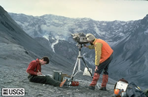
Ground deformation
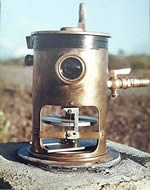 Rising magma can cause the ground above to swell or inflate. Geologists measure the rise and fall with tiltmetres,lasers,GPS and satellite radar.
A network of seismometers is placed around the volcano and readings relayed to a computer where the earthquake patterns can be analysed.A network of tiltmetres can pick up changes in inflation and deflation of the volcanoes surface.
Temperature changes
Infrared sensors both airbourne and hand held can be used to map the heat being given off by the volcano. The Infra-red sensors on satellites can also pick out volcano hotspots although resolution is limited by the sensor and will not be as detailed as plane data.
 Drainage and hydrology
Changes in the level of water in boreholes can be used to redict eruptions. Ananysis of river sediments and changes in river erosion rates can also help.
Satellite Remote Sensing
Satellites can be used to monitor volcanoes. Eruption clouds can be mapped and seperatd from normal clouds. Sulphur dioxide can be picked up using TOMS (Total Ozone Mapping Spectrometer) which is used normally for mapping Ozone. Thermal and deformation sensing can also be carried out from space.
Geomorpholgy
Historic paths of landslides,lahars,rockfalls and pyroclastic flows can be mapped to show likely routes in the future.
Volcanic Hazard Management
Volcanic Hazards fall under Geological and Geomorphological Hazards. Although volcanic eruptions are more predictable than earthquakes, there is very little if anything that man can do to prevent or alter the hazardous events happening. The only events people can occasionally have control over are the diversion of lava flows,lahars and lake gas. Ashfall,pyroclastic flows,fountaining,lava eruptions and lahars cannot be prevented from happening. It is how the risk is decreased to people that is the main strategy of volcanic hazard management.
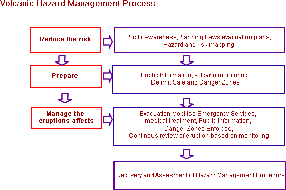
Practical Stategies
The main Strategy for preserving lives in the event of an eruption is Public Information.
- Public Preperation: making sure the public are prepared and know what to do before,during and after and eruption.
- Establish evacuation centres,routes and logistics
- Put out information on TV,radio or if need be personal contact
- Drills and Sirens
- Clear up teams
- Co-ordination of emergency Services
- Exclusion Zones
- Hazard and risk maps and land use planning.
Monitoring and Prediction
Monitoring of volcanoes has led to increasing success in predicting volcanic eruptions. The United States,Italy and Japan are the leaders in this field. See the monitoring TAB for more.
Sakurajima, Japan
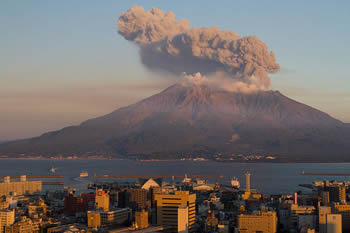 Sakurajima is possibly one of the most monitored volcanoes on earth. The Sakurajima Volcano lies near Kagoshima City, which has a population of 500,000 people. Both the Japanese Meteorological Agency (JMA) and Kyoto University Sakurajima Volcanological Observatory (SVO) monitors the volcano's activity.The volcano has been recently active since 1995 but no lava.The following show how Japan has learnt to monitor and predict the volcano. The following pattern of observations have been shown to be a precursor to an eruption at Sakurajima.
- swelling of the land around the volcano as magma below begins to build up.
- Earthquakes between 2-5km below the surface shows that magma is pushing upwards.Sak* has a tunnel deep into the mountain to measre the earthquakes.
- Bore holes with temperature sensors detect rises in temperaure. The amount of HCl and released SO2 increases , remote sensing is used to monitir the gases.
- The Sakursjima Volcanic Observatory s network of tiltmeters detect every movement of the mountain, even the smallest movement can herald and eruption.
- Seismometers detect earthquakes which occur immediately beneath the crater, signaling the onset of the eruption. They occur 1 to 1.5 seconds before the explosion.
 Popocatepetl , long period events and Bernard Chouet
One of the leaders in eruption prediction is Bernard Chouet who has pioneered a technique of looking at long period earthquakes (harmonic tremors)beneath a volcano which are the result of gas being pressurised within the volcanoes plumbing. His theory was put to the test when the Mexican authorities evacuated 10s of 1000s of people away from Popocatepetl based on the prediction that there woud be an eruption in 2 days time. He was right, the eruption happened and noone was hurt. After the disaster at Armero caused by Nevado del Ruiz where warning signs had been disregarded this was a great success.
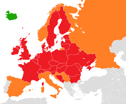
Soufriere Hills Volcano Montserrat
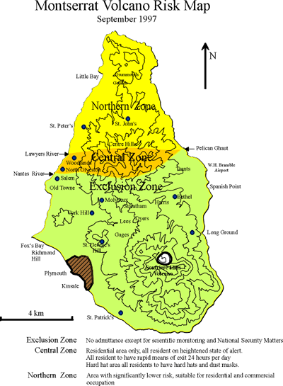 The small Caribbean Island of Montserrat is a good example of Managing the risk posed by a volcanic eruption. Montserrat is a small island(7x3 miles) from 1995 onwards the Soufriere Hills Volcano decimated the southern 23rds of the island. Monitoring,evacuation,public information and exclusion zones were used to minimise the risk to the public. The only deaths were caused by islanders flouting the danger zone restrictions and being caught up in a pyroclastic flow.The islands capital town,Plymouth,the airport and numerous houses and farms were destoyed by pyroclastic flows and could not be returned to. Montserrat is governed by the the UK so although so had the help of a wealthy nation to rebuild. A whole new infrastructure had to built to accomodate the population on the island. The map shows the hazard zoning on the island.
Mount Unzen 1991
 Mount Unzen in Japan had been dormant for nearly 200 years when increasingly frequent earthquakes,small steam and ash eruptions heralded the start of an active phase. A lava dome appeared in May 1991 and began producing pyroclastic flows. The governemnt issued an evacuation order and definded a restricted zone. The eruption increased in intensity and 12000 people were evacuated in June. Pyroclastic flows reached Shimabara City and destoyed empty homes. During March 1992 there 500 pyroclastic flows. Eventually the eruption clamed down in 1995 , the civilian population had been protected but 43 people from the media and sciencs had been killed when they knowingly went into the danger zone.
Volcanic Hazard Control
Lava Diversion on Etna
In 1991-1993 a lava flow from Mt Etna threatened the town of Zafferana .Efforts were made to divert the lava flow away from the town. First earth barriers were constructed but were overcome. Explosives were then used to disrupt a 7km long lava tube system which was feeding the lava front. On 23 May an explosion was set off which destroyed the lava tube and diverted the channel into a manmade channel. Ironicaly the eruption quietened down- but the town was safe.
Eldfell:Heimaey 1973
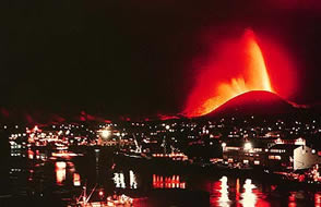 Eldfell is a cinder cone 200m high on the island of Heimay in the Vestmann islands off the south west cost of Iceland. At 1.55am on the 23 january a fissure 1800m long opened up from one shore to the other. A curtain of fire and lava shot into the air 200m only 1km from the only town of Vestmannaeyjir. The population were evacuated by the fishing fleet. Houses were soon buried in tephra and the lava started advancing towards the towns harbour which was vital for the towns fishing fleet and livelyhood. The population were determined to save their harbour and pumped millions of tonnes of sea water onto the advancing lava front to cool the advancing flow. It worked and the lava flow in the end enhanced the harbour entrance.